
 Data Processing & Visualisation
  Data Analytics, Insights & Applications
 The primary aim of the service is to expedite and simplify the project approval process for developers seeking certification. By incorporating forest carbon modeling and leveraging Earth Observation (EO) data, the service seeks to accelerate project operationalization, reducing the time required for approval. This integration of advanced technologies not only enhances efficiency but also brings transparency to carbon markets and attracts project financiers. The ForestHQ platform serves as the vehicle for delivering this service, offering additional features such as Measurement, Reporting, and Verification (MRV) tools and forest change monitoring. The overarching goal is to provide a comprehensive solution that not only streamlines project approval but also contributes to the broader goals of sustainable forest management and carbon emissions reduction, ultimately fostering a more accessible and transparent carbon market. Through these innovations, the service aims to catalyze positive environmental impact and support the broader ecosystem of stakeholders involved in forest carbon projects.
The users are in GHG mitigation projects for AFOLU, specifically forestry carbon projects for the voluntary carbon market. This includes project financiers, project developers, landowners including communities, land managers, auditing bodies, certifying agencies, NGO’s and policy makers. These projects are located globally with particular emphasis in South America and Africa with large scale deforestation and degraded land. The registration of forestry carbon projects is complicated, with specific criteria thereby causing a long delay in getting them vetted and available to the carbon markets. Projects with low levels of data and trust result in lower market prices for the credits. Small landowners and communities find the process daunting and have a desire to be more involved and understand the methodologies with the help of technology.
The main Satforcert user needs are:
Worldwide
The product is a comprehensive technology platform designed to simplify and enhance the carbon calculation process for users engaged in forest projects. Offering a user-friendly interface, the platform facilitates precise carbon quantity calculations, complemented by detailed reporting through maps, tables, and documentation. Integration of field plot data and project boundaries is seamless, incorporating a quality control process to ensure accurate carbon stock estimations. Emphasizing the importance of productive forest areas for carbon capture, the solution employs mapping techniques to exclude non-productive zones from calculations. The platform supports the integration of diverse satellite Earth Observation (EO) data, varying in resolution, enabling users to map and monitor forest regions effectively. Robust capabilities for EO data management and storage are integral to the platform’s functionality. Recognizing the need for specific documentation required by registries like Verra and Gold Standard, the platform digitizes templates and forms, offering a standardized service for information input. Ultimately, the product aims to empower users with a comprehensive, digitized ecosystem that optimizes forest project management, carbon calculations, and compliance with industry standards.
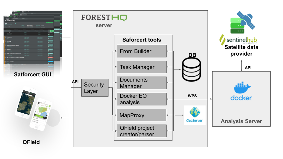
Various space assets, including a diverse set of Earth Observation (EO) datasets, play a crucial role in our solution. Low-resolution Sentinel-2 imagery proves valuable for monitoring and change detection across vast areas and at the forest stand level. On the other hand, higher resolution imagery like Pleiades enhances precision in greenhouse gas (GHG) calculations and enables detailed single-tree monitoring. The choice between high and low resolution involves a tradeoff between data cost and the accuracy of carbon calculation estimations. Opting for higher resolution data not only ensures more precise GHG estimations but also increases the value of traded credits, effectively offsetting the EO data cost. An innovative aspect of our solution lies in empowering users to assess different methodologies and choose a solution based on either cost-effectiveness or value maximization. This flexibility allows users to tailor their approach to specific project requirements, emphasizing a balanced consideration of cost and value in the decision-making process.
Following the successful completion of the pilot phase, Satforcert is now poised to enter its final pre-commercial phase before its official launch to the market. With very positive feedback from the validation users, the pilot phase demonstrated the system’s efficacy. Notably, mapping, satellite image acquisition, and analysis functionalities received particularly high ratings, underscoring the significance of EO data in Satforcert’s capabilities.
Overall, the successful validation of the Satforcert system underscores its potential to have a significant impact on forest management, carbon project development, and certification processes, contributing to enhanced transparency, efficiency, and sustainability in forestry practices.
As Satforcert progresses towards its market debut, interested parties can find more information at www.treemetrics.com.


 email
email  Facebook
  Twitter
  Linkedin
  Whatsapp
  Copy link