
 Data Analytics, Insights & Applications
 Floods are one of the most devastating natural disasters, accounting for the highest insured and uninsured losses annually, as well as costing many lives. With climate change possibly intensifying the hydrological cycle, the frequency and magnitude of extreme hydro-meteorological events, and therefore the risk of floods, are projected to continue to increase. This will be of devastating consequences, as it would put a greater strain on humanitarian response efforts and future financial risk of the global (re)insurance market.
Earth Observation data-based solutions currently provide a more advanced alternative to traditional ground-based flood monitoring methods or computer models, namely the ability to cover wider areas, frequent revisit times, abundant open access data and long historic image archives. However, there are still important challenges left unaddressed that compromise the quality and reliability of the data, such as the persistent cloud cover during floods, latency issues and the problem of getting abundant high-definition images under less favorable weather conditions and at night.
FloodSENS overcomes these issues by developing a flood mapping application that is capable of integrating a wider range of EO datasets and derivative data from digital elevation models using Machine Learning. This novel application being developed to market, seeks to efficiently reconstruct flooded areas under partial cloud cover in satellite images, thus creating far more reliable flood risk assessments and flood mapping during emergencies
FloodSENS is especially important for disaster response agencies at regional, national, and international level, who are keen to utilize the proliferation of open satellite data for flood mapping during emergencies. Additionally, in the insurance and re-insurance markets, stakeholders are interested in EO data to map the flood hazard of high-impact events and on a historical basis to understand risk exposure and the changing nature of it.
In the case of the flood disaster response markets, customers often have to deal with optical satellite imagery that is partly covered by clouds during flood events, where the data resolution is too low (>30 m pixel) )to allow for local scale flood analysis and they often lack resources to deal with complex EO image analysis. This inevitably compromises the humanitarian relief efforts as it leads to incomplete estimation of flood areas and thus misrepresentation of the real impact of the flood. The (re)insurance market struggles mainly with assessing the extent of flooding for high impact events, as well as understanding the potential flood risk exposure at a local-scale. This is due to many factors, including those referred to above, along with high costs in conducting on-site inspections, using incomplete EO data archives to build historical records and prediction models, and often lack of EO specialists.
FloodSENS is targeting both the humanitarian and disaster relief organizations, as well as the global (re)insurance market, with the aim of having the application work in diverse environments worldwide.
At an initial stage, as representatives of their respective customer markets, FloodSENS will have as partners and testing customers the United Nations World Food Programme (UN WFP), the National Disasters Management Institute of Mozambique (INGC) and Willis Re (re)insurance broker through Willis Towers Watson (WTW).
FloodSENS consists of a fully automated Machine Learning-based flood mapping algorithm, whose main characteristics include:
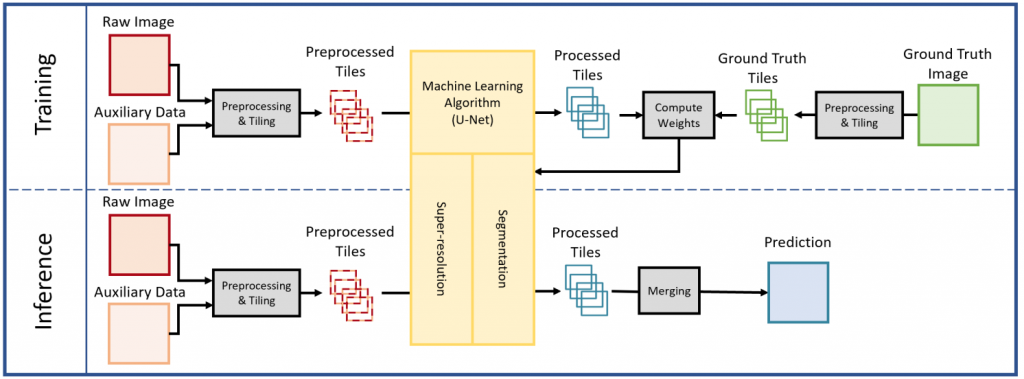
The schematic below, illustrates the FloodSENS algorithm structure, the overall architecture, and the key submodules.
The added value of FloodSENS centers around two major innovations:
In fact, for both Europe and the wider world, future Earth Observation-based and ML-powered apps would add considerable value to the existing products of the free Copernicus Emergency Management Service (EMS) and beyond. RSS-Hydro’s FloodSENS will place itself at the intersection of these two fields (EO technologies and AI/ML application tools) being at the forefront of future EO-enabled innovative solutions, to make a difference in allowing a much more effective disaster response.
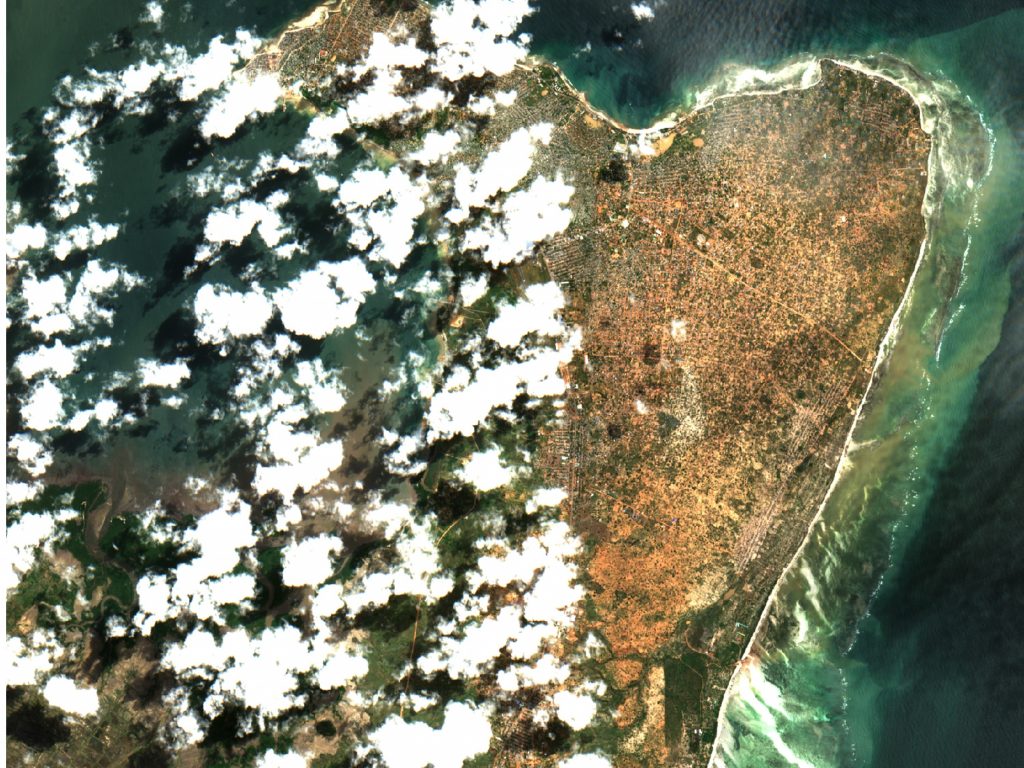
The ML model is based on the well-known U-Net architecture and uses Sentinel-2 (S-2) flood images and derivative layers from digital elevation models relating to topography and waterflow to map flooding even below partial cloud cover. The algorithm further employs a squeeze and excitation network to extract information about the importance of the different input layers. During the project, FloodSENS was trained on a large number expertly labelled S-2 flood images across different biomes, events and locations to ensure acceptable transferability, which is to become an important part of RSS-Hydro’s IPR of FloodSENS. Internal application testing and validation shows, unexpectedly, varying degrees of performance and accuracy. Overall, on average, FloodSENS performs at least as well as any robust and calibrated traditional band ratio index (>90% correct prediction), and in some cases outperforms such, and even maps below low cloud cover and correctly includes flood impact areas from dried out areas by following debris lines.
For the humanitarian stakeholder, it is clear that FloodSENS is an application they would start using since mapping consistently across different biomes given good transferability of the model will lower the number of missed flooded areas for them. For the financial risk industry, FloodSENS is appealing since the ML allows different trained models to be available for specific geographic areas where they are interested in, such as for example US, Europe, Australia and India because of a high number of insured assets in those areas. During the project, the FloodSENS app has been successfully deployed and demonstrated on the WASDI cloud processing platforms. Now that the R&D part is closed, both stakeholder segments will start the customer-led external validation on WASDI where they will test run FloodSENS and provide valuable feedback. RSS-Hydro will also organize a customer-oriented workshop with WTW to gather additional feedback to complete the best possible license subscription model.
Post-activity new steps/highlights
RSS-Hydro continues to improve FloodSENS and has some ongoing amazing new collaborations, namely:
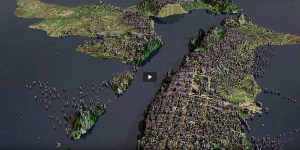
Link: Visualizing FloodSENS and Copernicus data with Omniverse
Bertrand.Le.Saux@esa.int

 email
email  Facebook
  Twitter
  Linkedin
  Whatsapp
  Copy link