
 Data Processing & Visualisation
  Data Analytics, Insights & Applications
 Earth Observation (EO) helps with the development and sustainability of businesses across many different sectors. The goal of this activity is to develop a platform for automated processing of EO imagery that helps clients identify cost-effective operational solutions, particularly when it comes to planning, maintaining and monitoring of their assets.
This activity aims to provide quality service using freely available satellite imagery, advanced analytics, up-to-date technology, and operational efficiencies by reducing costs. CGI SatSight achieves all of these functionalities with an emphasis on universality, extensibility, scalability and host-independent open source architecture.
CGI SatSight offers a scalable infrastructure, distributed processing and data independency, and fully automated algorithms for downloading and processing EO data. The product is cost-effective since there is no need to purchase and maintain specialised hardware or software. It also offers an innovative and flexible solution where the client can either directly integrate into existing systems or use as a stand-alone application. The client can also choose whether to run the whole processing chain on the cloud or on their premises.
Current methods for monitoring of vast infrastructures such as terrain and aerial controls are ineffective, time consuming and costly. They are also prone to mistakes caused by human factors. While there are some existing monitoring methodologies and systems, the majority are not universal to different analyses nor can they be fully tailored to clients’ needs. This presents an issue since every sector of interest has specific problems and some operators do not monitor their assets periodically nor continuously.
The CGI SatSight solution is ideal for clients that need to monitor vast areas of interest such as Oil & Gas, Energy and Utilities, Transport, Finance or Public sectors
The solution may be of use to clients worldwide.
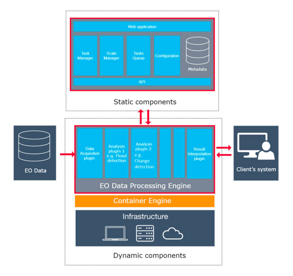
CGI SatSight is a solution for fully automated satellite image processing. The product chooses available data, downloads it, performs scalable processing and analysis, and then presents results through a notification to the user.
The technical functionalities of this product ensure clients from various sectors and industries can analyse the following use cases of this activity:
The activity brings a complete and universal solution that offers a fully automated, scalable and distributed infrastructure. It also provides openness and universality for different types of analysis and plug-in architecture that reduces implementation and usability requirements.
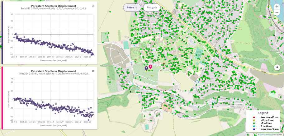
In addition, the client can decide whether to integrate the platform into their existing systems or use it as a stand-alone application. The activity has also developed four initial use cases: analyses of flood detection, change detection and two for vertical land movement.
While the initial focus of the project was on Oil and Gas clients, the platform can be expanded into a wide range of businesses. As well as processing satellite imagery, the platform infrastructure can be used for a variety of space and non-space applications (e.g. image document and video processing) that require high computing power.
The project is in its last quarter period. All customers’ and users’ needs were identified, verification and validation plans defined. The development of the technical platform and its web application has finished. Methodology and algorithmisation for all four use cases are done. The flood detection has been successfully implemented into the core of the platform.
The following steps of the project will be devoted to implementing the land movement use case and the improvement of the web application to suit the interferometry character and maintain a good user experience. Potential customers are continuously interviewed, and new areas and further development for the solution are sought.
The basic part of the project was successfully completed. Whole platform and dedicated use cases were developed, tested and implemented. The frontend of the web application was highly improved to ensure smooth and comfortable user experience. Negotiations with potential customers are still ongoing, but even at the end of the project the platform was used for trial operation for some clients. The platform is open for new use cases according to clients’ needs


 email
email  Facebook
  Twitter
  Linkedin
  Whatsapp
  Copy link